Haywood Hamlets: Small Close-Knit Communities Share Rural Living

The cities of Brownsville and Stanton may be the central, beating hearts of Haywood County, but within the county lie numerous cultures within cultures, small communities that launched lives, set boundaries, embraced inhabitants and shared struggles. The City of Brownsville sits in the center of Haywood County. County seat Brownsville and Stanton are the only two incorporated municipalities within the county.
But it is a matter of close-knit pride to hail from one of the smaller communities. Which community you call home can say much. It can tell who your friends, neighbors and relatives are, your school and, sometimes, even the church where your birth and marriage are recorded.
These small rural hamlets have histories as rich and long as the larger two. Why and where they sprouted may have been due to proximity to a railway or riverboat landing or because they grew up at the crossroads of major thoroughfares.
Some communities developed around the enterprises of the area’s first settlers and large landowners. Cotton gins were once common in most. Other remote neighborhoods sprung up because of proximity to Haywood’s two rivers—the Hatchie and South Forked Deer—for travel/crossing purposes.
Stores, schools, churches, and small businesses may have held these communities together at one time, but times change. Today, though many of these areas still have churches, the country schools were consolidated in the 1970s, and most community stores closed. Now, what holds the communities together is typically family-owned land legacy or the benefits of rural living.
With the advent of BlueOval City, times are again changing, and many of these rural communities face opportunity for renewal and growth.
Here is a quick look at some of Haywood County’s smaller communities. Portions of this information come from the Historical Commemorative Booklet, published in 1973 to coincide with Haywood County’s Sesquicentennial Celebration. Updates were added in the Heart of the Tennessee Delta: A Historical Guidebook to Haywood County. Copies of the latter are sold at the Elma Ross Library to benefit the Historical Society.
1. Allen/Allen Station
Location: Tennessee Highway 79, east of Brownsville, Tennessee.
Long ago, the community had a grist mill, a sawmill and two stores. The proximity of the railroad was a plus; four trains once stopped at Allen Station.
The first Allen Baptist Church was built in 1901. A newer church building adjoins Highway 79 today.
2. Bethel/Belle Eagle/Rudolph Area
Location: Northern part of the county, all along Rudolph Road and in proximity to the South Forked Deer River bottomland.
The area has also been called Stockton or even Stoggum Bottom. One account states a landowner named Stockton raised hogs in the lowland area, thus the name.
Gibson Kendrick moved into the area around 1870 and established a sawmill. The first school was established at Bethel in 1875. By 1890 there were two stores. Bethel Church was also built in the community’s preliminary stages.
3. Dancyville
Location: Southern Haywood County on Highway 76, between Brownsville and Somerville. It is about five miles from Interstate 40.
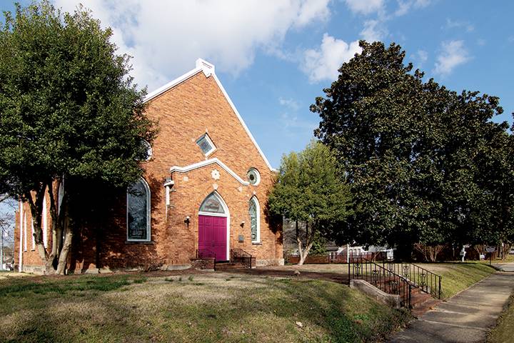
There are a couple of churches and a restaurant. Dancyville United Methodist Church is reported to be the oldest Methodist Church in West Tennessee. Its most unique features are its matching two front doors.
4. Douglass
Location: Southern portion of Haywood, along Route 179/Douglass Loop and south of Interstate 40.
The Douglass family once owned 5,000 acres and supported schools and churches and families in the community with farm employment. The federal government bought the land in the 1930s and subdivided it into parcels for homes.
There is a community center and church located here.
5. Forked Deer
Location: Northern part of Haywood County along Tibbs-Forked Deer Road.
The community is located on land granted by North Carolina in 1785. It was named for the nearby Forked Deer River. The first church was built there in 1884. Dr. Samuel Bain established the community’s first school. It was also one of the first communities to have mail service via pony express to Brownsville.
6. Hillville
Location: The southern part Haywood, with many residents living along Hillville Road.
The community was initially called Moore’s as first elections were held in the home of Alfred Moore. Later, renamed for Fountain P. Hill, in whose home the first post office was established, Hillville was once a stagecoach stop between Nashville and Memphis. The coach ferried across the Hatchie from Estanaula Landing, located not far from the southern portion of Hatchie National Wildlife Refuge.
7. Koko
Location: South of Brownsville near Tennessee Highway 76. Close in proximity to Interstate 40 and Hatchie National Wildlife Refuge.
There is a community store. The community name is said to have come from a popular brand of chewing gum at the time. Its proximity to Lowery’s Landing at the Hatchie River made it a busy area in earlier days.
8. Nutbush
Location: Western part of Haywood County, on Tennessee Highway 19, between Brownsville and Ripley.
A cotton gin and churches are located here. Other than its unique name, this community’s main claim to fame is as the birthplace of world-renowned entertainer Tina Turner, who was born Anna Mae Bullock.
9. Providence
Location: Eastern portion of Haywood County, on Providence Road, north of Interstate 40.
Providence Methodist Church, nicknamed “Do Me Good,” and cemetery, established circa 1860, are the community’s most prominent landmarks.
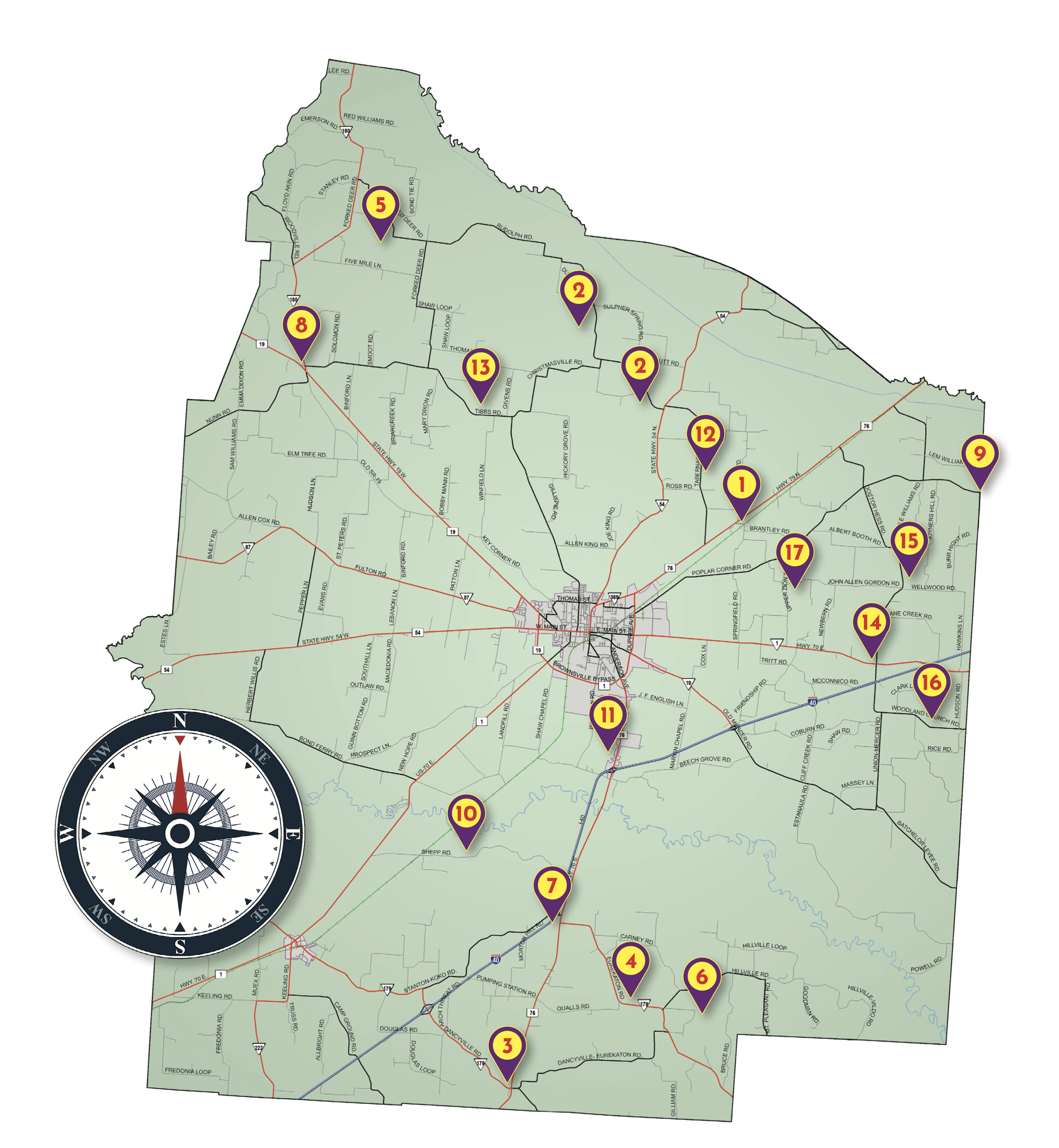
10. Shepp
Location: Southern part of county, south of Hatchie River on Shepp Road, between Highway 70 W and Interstate 40.
This community is named for Thomas Sheppard who once had a contract with the railroad company to keep the wooden water tank filled for the trains. Originally called Sheppard’s Switch, the name was shortened. An old one-room school/church still stands there.
11. Sunny Hill
Location: South of Brownsville, along Tennessee Highway 76, near Interstate 40.
Community is the namesake for Sunny Hill School, located in Brownsville, also on U.S. Highway 76/Anderson Avenue.
12. Tabernacle
Location: Between Brownsville and Bells, north of Tennessee Highway 79 on Tabernacle Road.
Centerpieces of the community are Tabernacle Church and cemetery and the historic Taylor Family Campground.
13. Tibbs
Location: Northern portion of the county on Tibbs Road.
The community was first known as New York and was settled around 1822. Residents later voted to change the name.
Today, there is a gin and a church in the community.
14. Union
Location: East portion of county along U.S. Highway 70 about two miles west of an intersection with Interstate 40.
There is a gin, a store, and a United Methodist church located in the heart of this community.
15. Wellwood
Location: Dr. Hess Road between Highway 70 and Highway 79.
Wellwood began in the late 1700s and early 1800s on an old stagecoach line from Jackson, Tennessee, to Brownsville and Bells. At one time the community was larger than all three, boasting a hotel, theater, post office, livery stable, grist mill, schools, churches, mercantile stores, and a phone exchange.
16. Woodland
Location: The southeastern part of the county on Woodland Baptist Church Road.
This community was settled in the 1800s, and Woodland Baptist Church is still in operation today.
17. Zion
Location: East of Brownsville, and north of Tennessee Highway 70, on Zion Road.
Zion Baptist Church was established in 1836 and is still the community’s centerpiece.